|
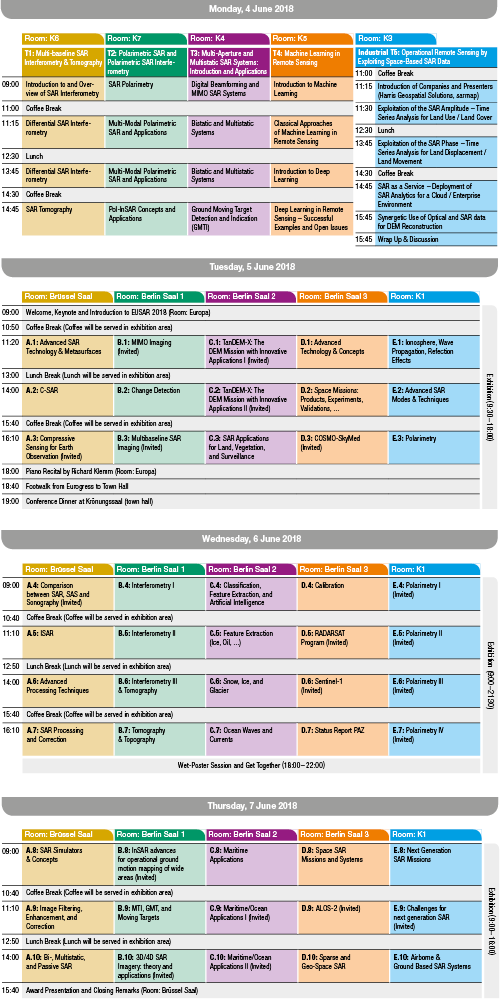
Download the preliminary program of EUSAR 2018 |
|

|
We are very pleased to welcome our keynote Speakers:
|
 |
|
Abstract: The age of spaceborne radar remote sensing was born in 1978 with the launch of SEASAT, an experimental satellite carrying an array of microwave instruments – a radiometer, an altimeter, and a synthetic aperture radar. Designed by NASA’s Jet Propulsion Laboratory, SEASAT demonstrated in its short lifespan the uniqueness and utility of radar’s all-weather day/night capabilities. Much as the rediscovery and repurposing of the knowledge from classical times led to the European Renaissance, the past decades since SEASAT have seen the repurposing of originally military technology and techniques toward a sustained and accelerating international growth in the number and variety of radar instruments that are orbiting Earth and the planets to understand where we live – a Radar Renaissance. Spacefaring nations now consider Earth imaging radar to be critical to their scientific and operational needs, and a growing number of systems are being launched around the world. Radars of all varieties are producing essential climate records, with a scientific imperative for continuing measurements.
This talk presents an overview of the major developments in spaceborne Earth and planetary radar systems, with some emphasis on NASA/JPL missions. The talk will highlight the intersections of science and innovation in spaceborne radar developments, including some of the most interesting science and technology achievements obtained over the years, and describe upcoming initiatives that support future directions in Earth and planetary observations.
|
|
|
 |
|
Abstract: Utilization of the Earth orbital regime is growing at a rapid pace and space situational awareness (SSA) has become of great interest to all. A major component of SSA is characterization of unknown objects. Characterization includes assessment of orbit, size, shape, orientation and functionality. Imaging is a very useful mechanism to characterize objects and the primary metric of imaging capability is resolution. To characterize an object, it must be resolved into many resolution cells; therefore, resolution cell size must scale with the size of the object. To characterize small satellites, resolution of the order of a few centimeters is required.
Ground-based optics provide limited imaging capability of orbiting objects due to poor resolution at the ranges of interest and susceptibility to adverse weather. Ground-based inverse synthetic aperture radar (ISAR) imaging has several advantages over ground-based optical imaging. It is more tolerant to weather, resolution is not a function of range, and since it provides its own illuminating signal, it is available at all times of the day. Ground-based systems are less costly and are easier to maintain and upgrade than space based systems.
MIT Lincoln Laboratory developed the Haystack Ultra-wideband Satellite Imaging Radar (HUSIR) to provide high-resolution images of objects orbiting the earth. HUSIR is a large dual-band monostatic radar with an instantaneous bandwidth of 1 GHz at X band and 8 GHz at W band, thereby providing fundamental resolution of 25 cm at X band and 3 cm at W band. This presentation will review the HUSIR design and will highlight the challenges that were faced in implementing that design.
|
|
|
 |
|
Abstract: The ocean covers more than 70 percent of the surface of our planet. Detailed information of the seabed at large depths is increasingly important in many fields such as marine biology, marine geology, offshore constructions and installations, and military applications. With the advent of unmanned autonomous underwater vehicles capable of operating at large depths, there is a need for high performance imaging sensors, and synthetic aperture sonar (SAS) is becoming the tool of choice for very high resolution imaging and mapping of the seabed. Although not as sophisticated and mature as state-of-the-art in SAR, modern SAS is relatively capable, being ultra-wideband widebeam multi-element interferometric systems with theoretical geometrical resolution better than 3 x 3 cm. The ocean environment imposes challenges for the synthetic aperture technique. Accurate positioning is non-trivial in the absence of GPS and stable platforms. The sound speed can vary up to 3% and cause substantial refraction. In this talk, we describe the similarities and differences between SAR and SAS, and the particular challenges in SAS. We show example SAS images from various places for different types of applications. |
|